Use of Remote Sensing
in Natural Resource Management
Prepared and presented by D. Lichaa El-Khoury
1.
What is Remote Sensing?
For the purposes of this course, we will use the following
general definition: “Is the technology of measuring the characteristics of an
object or surface from a distance”.
In the case of
earth resource monitoring, the object or surface is on the land mass of the earth or the sea,
and the observing sensor is in the air
or space.
In order for an observing sensor to acquire knowledge
about remote object, there must be a flow of information between the object and
the observer. There has to be a carrier of that information. In our case, the
carrier is the electromagnetic radiation (EMR).
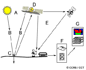
Figure 1:
Electromagnetic radiation
Hence, the main elements in the process of data collection
in remote sensing are the object to be studied, the observer or sensor, the EMR
that passes between these two, and the source of the EMR.
The process of remote sensing involves an interaction
between incident radiation and the targets of interest. The figure above shows
the imaging systems where the following seven elements are involved. Note,
however that remote sensing also involves the sensing of emitted energy and the
use of non-imaging sensors.
Figure 2:
Electromagnetic Remote Sensing of the Earth Surface
1.
Energy Source or Illumination (A) - the first requirement for remote
sensing is to have an energy source which illuminates or provides
electromagnetic energy to the target of interest.
2.
Radiation and the Atmosphere (B) - as the energy travels from its source
to the target, it will come in contact with and interact with the atmosphere it
passes through. This interaction may take place a second time as the energy travels
from the target to the sensor.
3.
Interaction with the Target (C) - once the energy makes its way to the
target through the atmosphere, it interacts with the target depending on the
properties of both the target and the radiation.
4.
Recording of Energy by the Sensor (D) - after the energy has been scattered by,
or emitted from the target, we require a sensor (remote - not in contact with
the target) to collect and record the electromagnetic radiation.
5.
Transmission, Reception, and Processing
(E) - the energy recorded
by the sensor has to be transmitted, often in electronic form, to a receiving
and processing station where the data are processed into an image (hardcopy
and/or digital).
6. Interpretation
and Analysis (F) - the
processed image is interpreted, visually and/or digitally or electronically, to
extract information about the target which was illuminated.
7.
Application (G) -
the final element of the
remote sensing process is achieved when we apply the information we have been
able to extract from the imagery about the target in order to better understand
it, reveal some new information, or assist in solving a particular problem.
2.
What are the different remote sensing systems?
So far, we know
that remote sensing imply a sensor fixed to a platform (usually satellite or
aircraft), which detect and record radiation reflected or emitted from the
earth’s surface.
The sensor mechanisms are very variable, and each has a
distinct set of characteristics, but the main points are:
a) The sensor can be an active system (where the satellite or
the aircraft provides the source of illumination, this technique is used when
no suitable natural source of radiation exists), or be a passive system (the source of the object illumination is
independent of the sensor and it is a natural source).
b) A variety
of different parts of the electromagnetic spectrum can be used including:
·
Visible wavelengths and reflected infrared (imaging
spectrometer): Remote sensing in
the visible and near infrared (VNIR) wavelengths usually falls into the passive
category. Here the sun is the source of the irradiance on the object being
observed. The sensor collects the solar radiation which is reflected by the
object. Active remote sensing occurs at these wavelengths only in the rare case
where an aircraft carries a laser as the source of illumination.
Blue,
green, and red are the primary colors or wavelengths of the visible spectrum.
They are defined as such because no single primary color can be created from
the other two, but all other colors can be formed by combining blue, green, and
red in various proportions.
·
Thermal sensors: Remote sensing in the thermal-infrared
wavelengths usually falls into the passive category, but in this case, the
source of the radiation is the object itself. There is no irradiance and the
sensor detects radiation which has been emitted by the object.
·
Microwaves (radar): These are used in the active remote
sensing systems. The satellite or aircraft carries an antenna which emits a
microwave signal. This signal is reflected by the ground and the return signal
is detected again by the antenna.
The figure below shows the sections of the electromagnetic spectrum most
commonly used in remote sensing
Figure 3: The electromagnetic spectrum
Each part of the spectrum has different characteristics
and gives rather different information about earth’s surface. In addition,
different surface covers (vegetation, water, soil, etc) absorb and reflect
differently in different parts of the spectrum. Different wavebands in the
electromagnetic spectrum therefore tend to be useful for different purposes.
c) The sensor may be sensitive to a single
portion of the electromagnetic spectrum (e.g. the visible part of the spectrum,
like panchromatic film which is sensitive to the same wavebands as our eyes).
Alternatively, it may be able to detect several parts of the spectrum
simultaneously. This latter process is called multispectral sensing.
d) Sensor
equipment takes many shapes and forms, such as cameras, scanners, radar,…
Figure 4: Active versus Passive sensors
3. Radiation target interaction
Radiation that is
not absorbed or scattered in the atmosphere can reach and interact with the Earth's
surface. There are three forms of interaction that can take
place when energy strikes, or is incident upon the surface. These are
absorption, transmission, and reflection. The total incident energy will
interact with the surface in one or more of these three ways. The proportions
of each will depend on the wavelength of the energy and the material and condition
of the feature.
Absorption occurs
when radiation is absorbed into the target, while transmission occurs when
radiation passes through a target. Reflection occurs when radiation
"bounces" off the target and is redirected. In remote sensing, we are
most interested in measuring the radiation reflected from targets.
Let's take a look at a couple of examples of targets at
the Earth's surface and how energy at the visible and infrared wavelengths
interacts with them.
Vegetation:
Chlorophyll strongly absorbs radiation in the red and blue
wavelengths but reflects green wavelengths. Leaves appear "greenest"
to us in the summer, when chlorophyll content is at its maximum. In autumn,
there is less chlorophyll in the leaves, so there is less absorption and
proportionately more reflection of the red wavelengths, making the leaves
appear red or yellow (yellow is a combination of red and green wavelengths).
The internal structure of healthy leaves act as excellent diffuse reflectors of
near-infrared wavelengths. If our eyes were sensitive to near-infrared, trees
would appear extremely bright to us at these wavelengths. In fact, measuring
and monitoring the near-IR (NIR) reflectance is one way that scientists can determine
how healthy (or unhealthy) vegetation may be. Vegetation could be
differentiated using NIR sensors, e.g. deciduous trees have a higher
reflectance than the coniferous in NIR.
Figure 5:
Vegetation reflectance in VNIR
Water:
In the visible region of the spectrum, the transmission of
the water is significant and so both the absorption and the reflection are low.
The absorption of water rises rapidly in the NIR where both transmission and
reflection are low.
Soil:
Soil has very different characteristics in the VNIR. The
increase of reflection with wavelength in the visible is consistent with the
human eye’s observation that soils can have a red or brown color to them.
We can see from these examples that, depending on the
complex make-up of the target that is being looked at, and the wavelengths of
radiation involved, we can observe very different responses to the mechanisms
of absorption, transmission, and reflection. By measuring the energy that is
reflected (or emitted) by targets on the Earth's surface over a variety of
different wavelengths, we can build up a spectral response for that object. By comparing
the response patterns of different features we may be able to distinguish
between them, where we might not be able to, if we only compared them at one
wavelength. For example, water and vegetation may reflect somewhat similarly in
the visible wavelengths but are almost always separable in the infrared.
Spectral response can be quite variable, even for the same target type, and can
also vary with time (e.g. "green-ness" of leaves) and location.
Knowing where to "look" spectrally and understanding the factors
which influence the spectral response of the features of interest are critical
to correctly interpreting the interaction of electromagnetic radiation with the
surface.

Figure 6: Spectral curve
Figure 7: Coniferous versus deciduous
trees spectral curves VNIR
4.
How data is recorded?
The detection of
the electromagnetic energy can be performed either photographically or electronically:
·
The photographic process uses chemical reactions on the
surface of light-sensitive film to detect and record energy variations.
·
An image
refers to any pictorial representation, regardless of what wavelengths or
remote sensing device has been used to detect and record the electromagnetic
energy
It is important
to distinguish between the terms images and photographs in remote sensing.
A photograph refers specifically to images that have been
detected as well as recorded on photographic film. The black and white photo
below was taken in the visible part of the spectrum. Photos are normally
recorded over the wavelength range from 0.3 mm to 0.9 mm - the visible and
reflected infrared. Based on these definitions, we can say that all photographs
are images, but not all images are photographs. Therefore, unless we are
talking specifically about an image recorded photographically, we use the term
image.

A photograph
could also be represented and displayed in a digital format by subdividing the
image into small equal-sized and shaped areas, called picture elements or pixels, and representing the brightness of
each area with a numeric value or digital number. Indeed, that is exactly what
has been done to the photo above. In fact, using the definitions we have just
discussed, this is actually a digital
image of the original photograph! The photograph was scanned and subdivided
into pixels with each pixel assigned a digital number representing its relative
brightness. The computer displays each digital value as different brightness
levels. Sensors that record electromagnetic energy, electronically record the
energy as an array of numbers in digital format right from the start. These two
different ways of representing and displaying remote sensing data, either
pictorially or digitally, are interchangeable as they convey the same
information (although some detail may be lost when converting back and forth).
5.
On the ground, in the air, in space
We learned so far some of the fundamental concepts
required to understand the process that encompasses remote sensing. Now we will
take a brief look at the characteristics of remote sensing platforms.
Ground-based sensors are often used to record detailed
information about the surface which is compared with information collected from
aircraft or satellite sensors. In some cases, this can be used to better
characterize the target which is being imaged by these other sensors, making it
possible to better understand the information in the imagery. Sensors may be
placed on a ladder, tall building, cherry picker, crane, etc.
Aerial platforms are primarily stable wing aircraft, although helicopters are
occasionally used. Aircraft are often used to collect very detailed images and
facilitate the collection of data over virtually any portion of the Earth's
surface at any time.
In space, remote
sensing is sometimes conducted from the space shuttle or, more commonly, from satellites.
Satellites are objects which revolve
around another object - in this case, the Earth. For example, the moon is a
natural satellite, whereas man-made satellites include those platforms launched
for remote sensing, communication, and telemetry (location and navigation)
purposes. Because of their orbits, satellites permit repetitive coverage of the
Earth's surface on a continuing basis.
Figure 8: Different remote sensing
platforms
6. Aerial photography
The figure below
shows how air photograph are obtained.
To cover the required area of ground photos are taken consecutively
along flight lines, which are usually parallel to each other across the area.
Figure 9: Obtaining aerial photographs
Two important
things are to be noticed here:
1.
Adjacent prints overlap with each other
è Along the flight lines by about 60%
è Between the flight lines by up to 20%
Why?
è There is no gaps in the cover
è Enables the photo to be viewed
stereoscopically
2. The photographs are
usually obtained with the camera pointing vertically down to the ground.
Why?
è Simpler geometry than those of oblique
angle
è Calculate the inherent distortions and
eliminate them.
7. Satellite imaging systems
Here we will
discuss briefly some of the currently orbiting satellites of commercial use.
Landsat 7
(ETM+):
American, is the
seventh of the Landsat series that were the first satellites to be launched in
the early seventies (1972).
Spectral bands
& pixel size
blue 30x30m
green 30x30m
red 30x30m
near infrared 30x30m
2 mid-infrared 30x30m
thermal infrared 120x120m
panchromatic 15x15m
Revisit period:
16 days
Scene size: 185 x
185 Km
Figure 10: Landsat system characteristics
SPOT:
French, was
launched in 1986. Is more accurate and with less distortion than the Landsat.
Spectral bands
& pixel size
green 20x20m
red 20x20m
near infrared 20x20m
panchromatic 10x10m
Revisit period:
26 days
Scene size: 60x60
Km
IRS-1C:
Indian. It was
launched in 1995. The ministry of agriculture has a full set of images for all
Lebanon.
Spectral bands
& pixel size
green 23x23m
red 23x23m
near infrared 23x23m
Shortwave
infrared 70x70m
panchromatic 5.8x5.8m
Revisit period:
24 days
IKONOS
Very recent
satellite.
Spectral bands
& pixel size
Blue 4x4m
green 4x4m
red 4x4m
near infrared 4x4m
panchromatic 1x1m
Revisit period: 3
days
Scene size:
11x11Km
KVR sovinformsputnik
Russian, used
previously for military purposes. It is launched for special missions, and the
film is dropped somewhere in Moscow.
The photos are then rasterized and sold as digital panchromatic images
with pixel size of 2x2m.
8. Image analysis
In order to take advantage of and make good use of remote
sensing data, we must be able to extract meaningful information from the
imagery.
Much
interpretation and identification of targets in remote sensing imagery is
performed manually or visually, i.e. by a human interpreter. Recognizing
targets is the key to interpretation and information extraction. Observing the
differences between targets and their backgrounds involves comparing different
targets based on any, or all, of the visual elements of tone, shape, size, pattern, texture, shadow, and association.
If a two-dimensional image can be viewed stereoscopically so as to simulate the
third dimension of height, visual interpretation will be much easier.
When remote
sensing data are available in digital format, digital processing and analysis may be performed using a computer.
Digital processing may be used to enhance data as a prelude to visual
interpretation. Digital processing and analysis may also be carried out to
automatically identify targets and extract information completely without
manual intervention by a human interpreter.
Digital image
processing may involve numerous procedures including formatting and correcting
of the data, digital enhancement to facilitate better visual interpretation, or
even automated classification of targets and features entirely by computer. In
order to process remote sensing imagery digitally, the data must be recorded
and available in a digital form suitable for storage on a computer tape or
disk.
At last but not
least, an important element in the image analysis is the integration of data.
In the early days of analog remote sensing when the only remote sensing data
source was aerial photography, the capability for integration of data from
different sources was limited. Today, with most data available in digital
format from a wide array of sensors, data integration is a common method used
for interpretation and analysis. Data integration fundamentally involves
the combining or merging of data from multiple sources in an effort to extract
better and/or more information. This may include data that are multitemporal,
multiresolution, multisensor, or multi-data type in nature.
Figure 11: Data integration from different
sources.
9. Applications
Natural resource
management is a broad field covering many different application areas as
diverse as monitoring fish stocks to effects of natural disasters (hazard
assessment).
Remote sensing
can be used for applications in several different areas, including:
q
Geology and
Mineral exploration
q
Hazard
assessment
q
Oceanography
q
Agriculture
and forestry
q
Land
degradation
q
Environmental
monitoring,…
Each sensor was designed with a specific purpose. With
optical sensors, the design focuses on the spectral bands to be collected. With
radar imaging, the incidence angle and microwave band used plays an important
role in defining which applications the sensor is best suited for.
Each application
itself has specific demands, for spectral resolution, spatial resolution, and
temporal resolution.
For a brief,
spectral resolution refers to the width or range of each spectral band being
recorded. As an example, panchromatic imagery (sensing a broad range of all
visible wavelengths) will not be as sensitive to vegetation stress as a narrow
band in the red wavelengths, where chlorophyll strongly absorbs electromagnetic
energy.
Spatial
resolution refers to the discernible detail in the image. Detailed mapping of
wetlands requires far finer spatial resolution than does the regional mapping
of physiographic areas.
Temporal
resolution refers to the time interval between images. There are applications
requiring data repeatedly and often, such as oil spill, forest fire, and sea
ice motion monitoring. Some applications only require seasonal imaging (crop
identification, forest insect infestation, and wetland monitoring), and some
need imaging only once (geology structural mapping). Obviously, the most
time-critical applications also demand fast turnaround for image processing and
delivery - getting useful imagery quickly into the user's hands.
Let as consider an application, in concrete the use of
remote sensing in the forest inventory. Forest inventory is a broad application
area covering the gathering of information on the species distribution, age,
height, density and site quality.
For species
identification, we could use imaging systems or aerial photos.
For the age and
height of the trees, radar could be used in combination with the species
information assessed at a first stage.
Density is
achieved mainly by an optical interpretation of aerial photos and/or
high-resolution panchromatic images.
As for site
quality, is one of the more difficult things to assess. It is based on
topological position, soil type and drainage and moisture regime. The
topological position can be estimated using laser or radar. However, the soil
type and drainage and moisture regime could be more profitably collected using
ground data.
The use of
Remote Sensing in Crop monitoring (real case)
The countries
involved in the European Communities (EC) are using remote sensing to help
fulfill the requirements and mandate of the EC Agricultural Policy, which is
common to all members. The requirements are to delineate, identify, and measure
the extent of important crops throughout Europe, and to provide an early
forecast of production early in the season. Standardized procedures for
collecting this data are based on remote sensing technology, developed and
defined through the MARS project (Monitoring Agriculture by Remote Sensing).
The project uses
many types of remotely sensed data, from low resolution NOAA-AVHRR, to
high-resolution radar, and numerous sources of ancillary data. These data are
used to classify crop type over a regional scale to conduct regional
inventories, assess vegetation condition, estimate potential yield, and finally
to predict similar statistics for other areas and compare results. Multisource
data such as VIR and radar were introduced into the project for increasing
classification accuracies. Radar provides very different information than the
VIR sensors, particularly vegetation structure, which proves valuable when
attempting to differentiate between crop types.
One the key applications within this project is the
operational use of high resolution optical and radar data to confirm conditions
claimed by a farmer when he requests aid or compensation. The use of remote
sensing identifies potential areas of non-compliance or suspicious
circumstances, which can then be investigated by other, more direct methods.
As part of the
Integrated Administration and Control System (IACS), remote sensing data
supports the development and management of databases, which include cadastral
information, declared land use, and parcel measurement. This information is
considered when applications are received for area subsidies.
This is an
example of a truly successfully operational crop identification and monitoring
application of remote sensing.
Link: http://staff.aub.edu.lb/~webeco/rs%20lectures.htm